Transportation
Expertise
Featured Projects

Future US 74
(NCDOT A-0009C)
Robbinsville & Stecoah
Graham County, NC
FUTURE US 74 (NCDOT A-0009C)

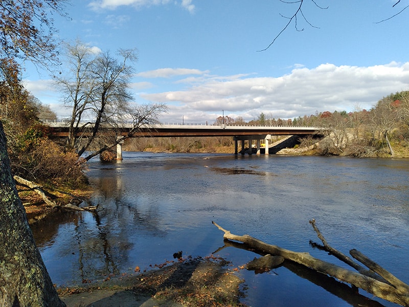
Biltmore Farms Bridge over French Broad River
Asheville
Buncombe County, NC
Biltmore Farms Bridge over French Broad River
CG2 had the opportunity to provide subsurface exploration investigations and geotechnical engineering recommendation services for the proposed construction of a new bridge at Biltmore Farms over the French Broad River in Asheville, North Carolina. Prior to mobilizing our drilling crew, CG2 conducted project site evaluations and oversaw land-clearing operations of the heavily wooded project area. CG2’s drilling crew team completed Standard Penetration Test (SPT) borings with regular interval split-spoon sampling, rock coring, and Shelby Tube sampling. CG2 drilled in total over 200 feet into the existing grades. Laboratory testing for this project included unconfined compressive strength testing of selected rock cores as well as soil testing (Atterburg Limits, NCDOT Hydrometer, Natural Moisture Test, Consolidation, AASHTO Classification) of the collected Shelby Tube. CG2 provided our client with Design Scour Memo, NCDOT Structure Subsurface Investigation Inventory, Structure Foundation Investigation and Recommendation, and Bent 1/ Bent 2 Supplemental Boring and Foundation Recommendation deliverables for the proposed construction of the new bridge.

Widen NC 191
(NCDOT R-2588B)
Mills River
Henderson County, NC
Widen NC 191 (NCDOT R-2588B)
Significant congestion on NC 191 in Mills River, North Carolina necessitates the existing two-lane facility to be widened. This project begins at the intersection of NC 191 with NC 280 and will end just south of the intersection with SR 1381 (Mountain Road) for an overall distance of 4.5 miles. The roadway construction consists of a 5-lane highway with two sets of multi-span dual bridges over the French Broad River and a tributary to the French Broad River will be constructed.
CG2 performed a total of 185 soil test borings, 15 hand auger borings, and 38 pavement cores with Kessler DCP testing using in-house and subcontracted drilling equipment. Challenges for this project included historic rainfall levels during the investigation, coordination with utility stakeholders for highly sensitive communication lines pervasive within the corridor, utilization of low-ground pressure and barge-mounted equipment, inundated test locations along the project corridor, and a local community largely opposed to the project. CG2 subcontracted the laboratory testing to aid in the development of recommendations. The CG2 team has completed the inventory and recommendations reports for the bridge, roadway, pavement, and retaining wall portions of the project. This project also includes a unique design for a mechanically driven earth anchor (MDEA) reinforced soil slope. The CG2 team completed our original scope of work as of April 2020.
Bald River Falls Bridge Replacement
Tellico Plains
Monroe County, TN
Bald River Falls Bridge Replacement
This multi-span bridge replacement project is located on Tellico River Road where it crosses Bald River Falls in Tellico Plains, Tennessee. The proposed bridge superstructure would consist of two spans on the order of 90 feet each and with an overlook to Bald River Falls. The proposed site consisted of challenging and difficult terrain with its mountainous features and substantial changes in elevation around the project area. CG2 conducted an explorative field investigation including five SPT borings with rock coring at select test sites. Rock cores were selected for unconfined compressive strength testing to aid in engineering deliverables. CG2 provided recommendations for the retaining walls supporting the bridge approach and shallow foundation design for the proposed bridge.
I-26 from I-40 to SR 3548 PDI
(NCDOT I-2513AA/AB)
Asheville
Buncombe County, NC
I-26 from I-40 to SR 3548 PDI (NCDOT I-2513AA/AB)
This NCDOT project consisted of the complete reconstruction of a section of I-40 at the I-26 interchange in Buncombe County, North Carolina. The existing concrete pavement is less than 10 years old and is showing signs of rapid degradation. CG2 provided the department with a Pavement and Subgrade Design Investigation utilizing in-house drilling equipment and personnel. Over six nights, CG2 performed 113 pavement cores with Kessler DCP testing on both I-40 and I-26. CG2 also subcontracted the lab testing for the recovered bulk samples and subgrade samples obtained from the investigation to prepare the final report. The investigation uncovered a relatively thick pavement section varying from full-depth asphalt to multiple layers of concrete separated by an asphalt bond breaker layer. At the conclusion of the investigation, NCDOT GEU requested CG2 prepare a cross-section subsurface report showing the individual pavement layers encountered in cross section view along the project corridor. Our geotechnical scope of work on this project was completed in May of 2022.
US 74 from Graham St. to SR 1749 PDI
(NCDOT R-5798)
Wadesboro
Anson County, NC
US 74 from Graham St. to SR 1749 PDI (NCDOT R-5798)
This NCDOT project is located along US 74 between Graham Street and SR 1749 in Wadesboro, North Carolina, and consists of a roadway widening roadway improvement. US 74 consists of four to five lanes with a bi-directional center turn lane or median and intermittent right/left turn lanes at numerous intersections. CG2 performed our investigative fieldwork during night-time working hours to avoid the high traffic volumes during the daytime hours. In total, CG2 collected 54 pavement cores and obtained 48 DCP Kessler readings. CG2 provided a Pavement and Subgrade Inventory Report deliverable following the guidelines in the NCDOT Geotechnical Investigation and Recommendations Manual. The deliverables included pavement coring logs, DCP measurements, pavement core photos, plan sheets showing the core data, and a summary of the lab testing results performed within the project. CG2’s geotechnical efforts were completed in September 2022.
NC 73 from Vance Rd. Extension/Beatties Ford Rd. to SR 5544 PDI
(NCDOT R-5721B)
Huntersville
Mecklenburg County, NC
NC 73 from Vance Rd. Extension/Beatties Ford Rd. to SR 5544 PDI (NCDOT R-5721B)
The project is located on NC 73 between West Catawba Avenue and Northcross Avenue in Huntersville, North Carolina. The existing road consists of a four to five lane divided highway with multiple intersections. The project scope will consist of widening NC 73 and improving the following existing intersections with NC 73; Kenton Drive, Northcross Drive, Birkdale Crossing Drive, Birkdale Commons Parkway and Lindholm Drive.
CG2 performed a total of 38 pavement cores with Kessler DCP testing using in-house exploration equipment. In addition, two bulk samples were collected along the corridor. To perform a Pavement Design Investigation, a 4-inch diameter thin-wall core barrel is used to obtain a sample of the pavement section. Once the subgrade is exposed, the Kessler DCP is driven approximately 4 feet into the subgrade to estimate the in-situ California Bearing Ratio (CBR) values. Once Kessler DCP testing is complete, the equipment is withdrawn, and a solid-stem auger is advanced approximately 5 feet below top of pavement to obtain a soil sample. The borehole is then backfilled with auger cuttings and sand and asphalt cold patch is placed to match the existing pavement section.
Challenges for this project included coordination with utility stakeholders, performing work during the night to avoid peak driving hours, and traffic management/control. CG2 subcontracted the laboratory testing and performed 25 AASHTO soil classifications and 2 CBR tests to confirm visual/manual soil classifications and estimate strength characteristics of potential fill materials. The CG2 team has completed all geotechnical work for this project.
Realign Union Cemetery Rd. to Intersect US 29 at Rock Hill Church Rd. PDI
(NCDOT U-5956)
Concord
Cabarrus County, NC
Realign Union Cemetery Rd. to Intersect US 29 at Rock Hill Church Rd. PDI (NCDOT U-5956)
CG2 provided drilling, laboratory, and geotechnical engineering services for the NCDOT roadway improvement project located along US 29 (Concord Parkway North/ South) and Union Cemetery Road in Concord, NC. Concord Parkway consists of four lanes with intermittent right/left turn lanes divided by a grass median. Union Cemetery Road consists of two travel lanes with an additional directional turn lane near the intersection with Cabarrus Avenue. The project will realign Union Cemetery Road to intersection US 29 at Rock Hill Church Road. The current intersection of Union Cemetery Road and Cabarrus Avenue will be eliminated by creating a cul-de-sac.
CG2 performed investigative fieldwork during night-time working hours to avoid high traffic volumes during the daytime hours. In total, the CG2 team collected 40 pavement cores and obtained 38 DCP Kessler readings. CG2 provided a Pavement and Subgrade Inventory Report deliverable following the guidelines in the NCDOT Geotechnical Investigation and Recommendations Manual. The deliverables included pavement coring logs, DCP measurements, pavement core photos, plan sheets showing the core data, and a summary of the lab testing results performed within the project. CG2’s geotechnical efforts were completed in October 2022.
City of Hickory City Walk
Hickory
Catawba & Burke County, NC
City of Hickory City Walk (NCDOT EB-6038)
The City of Hickory solicited professional services for the engineering and design of two segments of a multi-use path which includes a bike/pedestrian bridge. The 0.9-mile first segment follows along Main Avenue NW from 9th Street NW to 11th Street NW and then along 11th street NW to Old Lenoir Road. The 1.7-mile second segment begins at Old Lenoir Road and traverses along Clement Boulevard to US 321. The multi-use path then bridges over US 321 and continues along 19th Street Lane NW and Clement Boulevard to the Hickory Regional Airport. The project is part of the 2018 BUILD Grant “Hickory Reconnected Through Transportation Infrastructure Investment.”
Carolinas Geotechnical Group, PLLC (CG2) provided geotechnical and geoenvironmental subconsultant services on the project. Our responsibilities included performing a subsurface exploration and providing geotechnical recommendations for the roadway, bridges, retaining walls, and pavements. A total of 66 soil tests and hand auger borings to depths up to 60 feet below the existing ground surface were performed along the proposed alignment. In addition to the previously mentioned deliverables, CG2 provided engineered design drawings for two reinforced soil slopes with maximum slope heights on the order of 20 and 50 feet, respectively.
Middle Fork South Fork New River Pedestrian Bridges
Boone
Watauga County, NC
Middle Fork South Fork New River Pedestrian Bridges
CG2 was requested to perform a subsurface exploration and provide geotechnical engineering recommendations for two single-span pedestrian bridges for the Middle Fork South Fork New River for a future greenway in Boone, North Carolina. SPT borings with split-spoon sampling were advanced to sugar refusal materials upon which rock coring was preformed in select borings. Due to steep terrain resulting in drill equipment inaccessibility, rock coring was performed for one test site utilizing a portable rock core drill. Representative soil samples were selected for Atterberg limits, grain size analysis (with a hydrometer), and natural moisture content testing. Two rock samples were selected for unconfined compressive strength testing. CG2 provided the client with a detailed report including the site conditions encountered during the exploration, geologic information relevant to the project area, geotechnical engineering recommendations for site preparation and testing during construction activities, and bridge foundation support design recommendations for the proposed pedestrian bridges.
Sandy Creek Pedestrian Bridge
Franklinville
Randolph County, NC
Sandy Creek Pedestrian Bridge
CG2 conducted a subsurface exploration investigation and provided geotechnical engineering recommendations for a new pedestrian bridge over Sandy Creek to connect the Franklinville-Ramseur segment of the Deep River Trail in Franklinville, North Carolina. SPT soil borings were advanced to auger refusal materials and sampled at regular intervals with a split-spoon sampler. Then, representative soil samples were selected for laboratory analyses (Atterberg limits, grain size analysis with hydrometer, and natural moisture content) to evaluate the soil characteristics of the project area. We provided our client with our exploration and testing procedures and findings, geotechnical engineering recommendations for site preparation and testing during construction activities, and bridge foundation support design recommendations for the proposed pedestrian bridge.
Carter Falls Pedestrian Bridge
Elkin
Wilkes County, NC
Carter Falls Pedestrian Bridge
CG2 was requested to perform a subsurface exploration and provide geotechnical engineering recommendations for a new pedestrian bridge over Big Elkin Creek, just below Carter Falls, in Elkin, North Carolina. For this project CG2 was tasked with performing three SPT borings with regular interval split spoon sampling and rock coring at approximate end bent and anchor locations. One location was inaccessible to CG2’s drilling equipment due to steep terrain, as such, a hand auger boring was performed to refusal depth followed by rock coring utilizing a portable rock core drill. Three rock core samples were selected for unconfined compressive strength testing. CG2 subcontracted one seismic refraction survey to assist in evaluating the depth to PWR and bedrock. CG2 provided the client with information on the site conditions encountered during the exploration and geologic information relevant to the project area, field exploration findings, geotechnical engineering recommendations for site preparation and testing during construction activities, and recommended a Micropile foundation support design for the new pedestrian bridge.